
Center for GIS and Spatial Analysis
Welcome to the Center for Geographic Information Systems and Spatial Analysis (CGSA) at West Chester University.
For over 20 years, CGSA has been working to support teaching, research, and the local community, with the use of geospatial technologies. Housed in the Department of Geography & Planning, within the College of Business and Public Management, CGSA works with students, faculty and staff from across the University, and across multiple disciplines, to support the integration of GIS and other geospatial technologies into coursework, research, and management decision-making. CGSA also engages with local community partners to leverage the power of geospatial data and analysis to address local challenges with creative, data-driven, solutions.
CGSA can provide access to geospatial data, technical training, support for teaching with GIS, support for research with GIS, support for geospatial data management, and consulting services. Resources offered include access to geospatial data, mapping and cartography, building web maps, StoryMaps, and other web-based spatial resources, spatial visualization, 3D model development, drone flights, imagery analysis, and more.
Here are examples of what the Center for GIS and Spatial Analysis can do for you:
- Provide access to hardware, software, and data
- Provide support for individual research projects
- Provide support for classroom activities and resources
- Provide training and technical skill development
- Bring GIS users together to share ideas

Upcoming GIS and Planning Events
-

ESRI User's Conference, July 10-14, 2023 (Check back for more information)

Association of American Geographers Annual Meeting, Denver, CO, Mar 23 - Mar 27, 2023

2023 American Planning Association Conference, April 1-4, Philadelphia, PA

PA GIS Conference, April 10-12, 2023, Penn Stater Hotel & Conference Center
Check back for more information
-

PA Chapter of the American Planning Association Annual Conference, Oct 2-4, 2023 Lancaster PA

PARK(ing) Day 2022
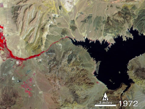
Las Vegas, 1972-2013